
The Nine Nations
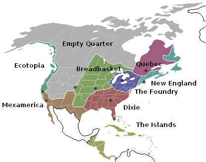
Written in 1981, Joel Garreau’s The Nine Nations of North America breaks the continent down into its most culturally relevant components. You may have noticed that I like maps.
New England: An expanded version including not only Maine, New Hampshire, Vermont, Rhode Island, Massachusetts and Connecticut (although omitting the Connecticut suburbs of New York City), but also the Canadian Atlantic provinces of New Brunswick, Nova Scotia, Prince Edward Island, and Newfoundland and Labrador. Capital: Boston.
The Foundry: The by-then-declining industrial areas of the northeastern United States and Great Lakes region stretching from New York City to Milwaukee, and including Chicago and Philadelphia as well as industrial Southern Ontario centering on Toronto. Capital: Detroit.
Dixie: The former Confederate States of America (today the southeastern United States) centered on Atlanta, and including most of eastern Texas. Garreau’s “Dixie also includes Kentucky (which had both Federal and Confederate governments); southern portions of Missouri, Illinois, and Indiana; and the “Little Dixie” region of southeastern Oklahoma. Finally, the region also includes most of Florida, as far south as the cities of Fort Myers and Naples. Capital: Atlanta.
The Breadbasket: Most of the Great Plains states and part of the Prairie provinces: Iowa, Kansas, Minnesota, Nebraska, the Dakotas, almost all of Oklahoma, most of western Missouri, western Wisconsin, eastern Colorado, the eastern edge of New Mexico, parts of Illinois and Indiana, and North Texas. Also included are some of Northern Ontario and southern Saskatchewan and Manitoba. Capital: Kansas City.
The Islands: The South Florida metropolitan area, the Everglades and Florida Keys, the Caribbean, and parts of Venezuela. Capital: Miami.
Mexamerica: The southern and Central Valley portions of California as well as southern Arizona, the portion of Texas bordering on the Rio Grande, most of New Mexico and all of Mexico, centered on either Los Angeles or Mexico City (depending on whom you ask), which are significantly Spanish-speaking. Garreau’s original book did not place all of Mexico within Mexamerica, but only Northern Mexico and the Baja California peninsula. Capital: Los Angeles.
Ecotopia: The Pacific Northwest coast west of the Cascade Range, stretching from Alaska down through coastal British Columbia, Washington state, Oregon and into California just north of Santa Barbara. Capital: San Francisco.
The Empty Quarter: Most of Alaska, Nevada, Utah, Wyoming, Idaho, Montana and Colorado from Denver west, as well as the eastern portions of Oregon, California, Washington, all of Alberta and Northern Canada (including what is now Nunavut), northern Arizona, parts of New Mexico (mainly the area controlled by the Navajo Nation), and British Columbia east of the Coast Ranges. Capital: Denver.
Quebec: The primarily French-speaking province of Canada, which held referenda on secession in 1980 and 1995, the latter of which the “separatists” lost narrowly. Capital: Quebec City.
You might like these textually similar articles: